About the Author
Kathryn Fenstermaker serves C. H. Fenstermaker & Associates as Corporate Communications Leader, working to support… (Read More)

Kathryn Fenstermaker serves C. H. Fenstermaker & Associates as Corporate Communications Leader, working to support… (Read More)
Late in August of last year, I was hired to work as Business Development Consultant for my family’s company, C. H. Fenstermaker & Associates, founded by my paternal grandfather, a professional engineer and land surveyor dating back to 1938. He surveyed for Artillery Units at Anzio during WWII and returned home to service the oil & gas industry. Charles Howard Fenstermaker, Jr. left a legacy in Louisiana. Today, the company’s evolution is evident as I work to promote an internally-developed Geographic Information Systems (GIS) digital mapping software, a far cry from the hand-drawn paper plats of yesteryear. The company has survived many ups and downs of the oil & gas industry — adapting and diversifying, evolving alongside technology, staying afloat during crises.
I came on board asking questions and conducting research, all the while gaining knowledge from my colleagues. The world of Geographic Information Systems was opening up to me one discovery at a time. A growing confidence and developing expertise in data visualization and digital mapping came fast as I engaged with our clients. GIS serves our vast population in a variety of ways, and I took immediate interest in our collaborative efforts to date with Calcasieu Parish in southwest Louisiana, a parish with a population of roughly 200,000, determined to digitize and consolidate relevant data that it may serve both governmental and public interests. Their GIS initiative has grown and flourished throughout the parish, bringing prosperity to bear.
In any organization, one measure of success is, perhaps, the adoption of currently available technology and its use to improve efficiency and communication. In this regard, the Calcasieu Parish Police Jury is exhibiting signs of success by investing in GIS that lead the state in their usefulness, providing the benefit of public awareness, as well as fostering internal efficiencies. The parish upkeeps parcel boundaries for assessments and revenue collection along with a myriad of data including districts, zoning, subdivisions, rain gauge and river stage data, along with infrastructure, mapping features such as bridges, streets, railroads, water systems, sewers, drainage and pipelines.
When I began exploring the datasets submitted by Calcasieu Parish for inclusion into their mapping application, I sought to delve deeper than peering at the polygons. I sought to learn about the organizations involved in the necessity for maintaining the information. For example, the parish showcased data pertaining to storm water zones, so I attended the Louisiana Urban Stormwater Coalition meeting where they discussed mitigating the impacts of impervious surface installation due to urban sprawl, and how having storm water masterplans in place could aid in tracking progress toward community flood protection. It was becoming increasingly clear to me the benefits of mapping these masterplans. It meant taking responsibility.
 Having a central repository for data not only raises awareness, but allows for swift response to disaster or emergency as data is made readily available for speedy analysis and effective decision-making. The Common Ground Alliance (CGA) has created a Damage Information Reporting Tool (DIRT) which aids in the production of an interactive DIRT Report. This caught my eye as I researched the rationale for mapping underground infrastructure. CGA representatives were so friendly when I called, telling me about their birth under the Pipeline and Hazardous Materials Safety Administration (PHMSA) and their mission to spread the word about damage prevention. This led me to contact Louisiana One Call, where I spoke with Executive Director David Frey, who encouraged me to attend and present at the Louisiana Damage Prevention Summit. There, I discussed Calcasieu Parish and the great strides they have made toward mapping geographical data and interrelated systems along with the impact this is having as they pursue the goals of protecting life, property, and infrastructure. The parish-wide GIS initiative plays an integral role in allowing for this commitment to hold.
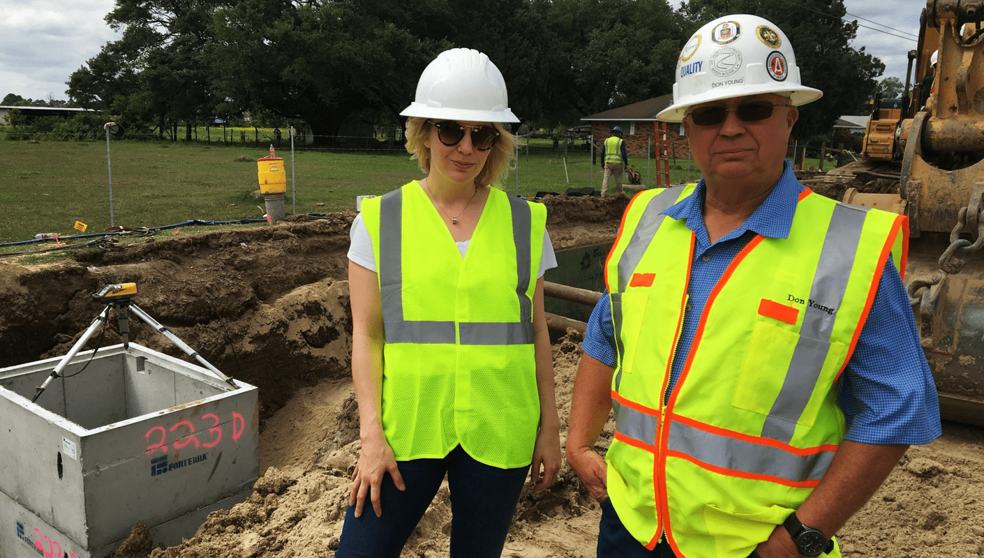
In preparing for the Damage Prevention Summit, excavation became a fascination and all of the heavy machinery and manpower caught my attention as I commuted to work. A road widening project was underway and I was so inspired that I set out to meet the superintendent, Mr. Don Young. He talked to me about the job, about progress impediments, and about the challenges of protecting underground infrastructure and utilities. He granted me the opportunity to walk the jobsite with him, and I took him up on his offer. Being out in the field, seeing those pipes being lowered deep into the earth, seeing an undocumented sewer line running interference on the new drainage system, hearing about how these challenges were being faced, and listening to the sounds of men and machines working together gave me a new perspective on our underground infrastructure and those who work to accomplish installation.
 I began connecting the dots; coming into view were the invisible lines that exist beneath the surface of the earth, as men dig blind to what may or may not lie below. With guidance provided in the form of marking flags and spray paint, they break the earth, encountering what is all too often surprising and dangerous. The appreciation we must hold for these machine operators who risk their lives in these trenches is worth going the extra mile to rethink strategies to protect them and the surrounding communities.
So the question becomes, “How can we revolutionize the damage prevention industry?” In pondering the answer, I encourage you to entertain the following: What would it look like if all underground utilities and pipelines present at project sites were surveyed in advance of excavation, and we were able to provide a comprehensive and accurate GIS platform for data display? Would a contractor be less likely to break lines if he or she were equipped with an omniscient, on-demand map engine? What if machine operators and crew foremen used augmented reality to visualize underground lines at the dig site? What if we were finally able to do away with marking flags and spray paint? These questions challenge the industry, challenge legislation, and challenge our litigious society, but isn’t that the very essence of revolution?
The CGA promotes a spirit of shared responsibility, and their promotions have not fallen on deaf ears. I know that my personal commitment to damage prevention began with awareness. It began with research, communicating with those involved, and engaging my clients to learn more and spread the word. To become a vehicle for this message has been a journey and although damage prevention is not my job, it has become my business. It has become my responsibility.
Discover our industry-leading products and service that our customers have been trusting in for decades. Whatever your need, we’re here.